Definition of Web Map in Network Encyclopedia.
What is Web Mapping?
Web mapping is the process of using the maps delivered by geographic information systems (GIS) in the World Wide Web. A web map on the World Wide Web is both served and consumed, thus web mapping is more than just web cartography, it is a service by which consumers may choose what the map will show.
Web GIS emphasizes geodata processing aspects more involved with design aspects such as data acquisition and server software architecture such as data storage and algorithms than it does the end-user reports themselves.
Types of web maps:
- Analytical web maps: Analytical web maps offer GIS analysis. The geodata can be a static provision, or needs updates. The borderline between analytical web maps and web GIS is fuzzy. Parts of the analysis can be carried out by the GIS geodata server. As web clients gain capabilities processing is distributed.
- Animated and realtime: Realtime maps show the situation of a phenomenon in close to realtime (only a few seconds or minutes delay). They are usually animated. Data is collected by sensors and the maps are generated or updated at regular intervals or on demand.
- Collaborative web maps: Collaborative maps are a developing potential. In proprietary or open-source collaborative software, users collaborate to create and improve the web mapping experience. Some collaborative web mapping projects are:
- Google Map Maker
- Here Map Creator
- OpenStreetMap
- WikiMapia
- meta:Maps – a survey of Wikimedia movement web mapping proposals
- Online atlases: The traditional atlas goes through a remarkably large transition when hosted on the web. Atlases can cease their printed editions or offer printing on demand. Some atlases also offer raw data downloads of the underlying geospatial data sources.
- Static web maps: Static web pages are view only without animation or interactivity. These files are created once, often manually, and infrequently updated. Typical graphics formats for static web maps are PNG, JPEG, GIF, or TIFF (e.g., drg) for raster files, SVG, PDF or SWF for vector files.
Web mapping technologies
Technologies in web mapping:
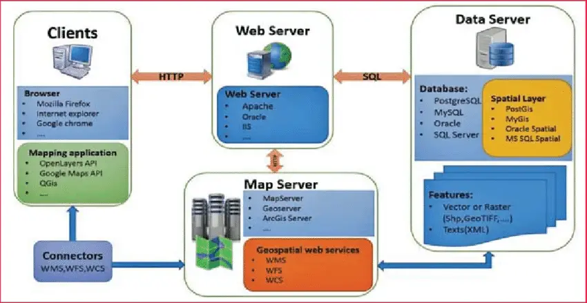
- Spatial databases are usually object-relational databases enhanced with geographic data types, methods, and properties. They are necessary whenever a web mapping application has to deal with dynamic data (that changes frequently) or with huge amount of geographic data. Spatial databases allow spatial queries, subselects, reprojections, and geometry manipulations and offer various import and export formats. PostGIS is a prominent example; it is open source. MySQL also implements some spatial features. Oracle Spatial, Microsoft SQL Server (with the spatial extensions), and IBM DB2 are the commercial alternatives. The Open Geospatial Consortium’s (OGC) specification “Simple Features” is a standard geometry data model and operator set for spatial databases. Part 2 of the specification defines an implementation using SQL.
- Tiled web maps display rendered maps made up of raster image “tiles”.
- Vector tiles are also becoming more popular—Google and Apple have both transitioned to vector tiles. Mapbox.com also offers vector tiles. This new style of web mapping is resolution independent, and also has the advantage of dynamically showing and hiding features depending on the interaction.
- WMS servers generate maps using parameters for user options such as the order of the layers, the styling, and symbolization, the extent of the data, the data format, the projection, etc. The OGC standardized these options. Another WMS server standard is the Tile Map Service. Standard image formats include PNG, JPEG, GIF, and SVG. Open source WMS Servers include UMN Mapserver, GeoServer and Mapnik. Commercial alternatives exist from most commercial GIS vendors, such as ESRI ArcIMS and CadCorp.